
Uffington / Baulking / Fernham

An 11 km walk from the village hall in Uffington looping out behind Baulking and back via
Fernham and Moor Mill
Buy a detailed map from the Ordnance Survey online shop.
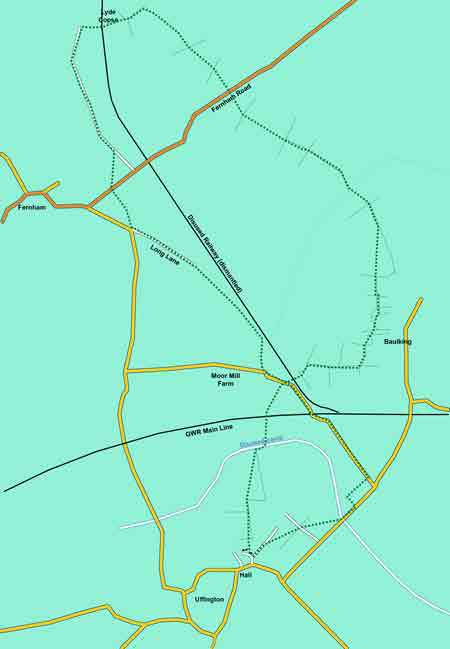
Note: This walk crosses the twin tracks of the main London to Bristol railway line. Trains give no warning of approach and extreme care will therefore need to be excised at this point of the walk.
The walk starts from Uffington’s village hall (the Thomas Hughes Memorial Hall). Cross the road running alongside the hall and go down the short road labelled “The Green leading to Lower Common Lane”. Bear to the left down a gravel road and, after 20m, take the footpath to the right – between the cottage and the first house. Follow the footpath across a paddock into a field and continue in a straight line across to the extreme right-hand corner of the field. Cross over the 2 stiles into the next field and, with a hedge on your right, continue for 30m. When the hedge bears sharp right, continue in your current direction (possibly over an electric cattle fence) across the open field until you the far right-hand corner of the field. Cross the two stiles on your right and, a few metres into the next field, bear left over a bridge across the old canal. You will now see the railway. Continue across this field to the railway embankment (to the point marked with a white sign). Climb the embankment and cross the rails descending the embankment the other side (note warning above). Now cross the field in front of you bearing slightly right to pass to the immediate left of the two barns ahead of you. Pass down the side of the barn out to the concrete apron of the farm yard. Once on the road, bear right and look for a stile on your left hand side (approx 30m).
Cross the style and the field to a field boundary opposite. Go through the two gates into the next field and continue - keeping the hedge on your left. The boundary will kink right after 100m or so. Continue up hill through the gap into the next field and continue ahead until you reach the next field corner. Here, bear left through the gate and continue forward – now with a field boundary on your right. When you reach the corner of this field, go through the gate in front of you and bear 45° right crossing diagonally across the next field towards the far right corner (a cattle pen has been erected in this corner). Go through the gate to the left of the cattle pen. Ignore the footpath to your right and continue straight ahead through a gate half way along an open wooden fence on your right hand side. Continue forward to the field boundary facing you and follow it right for a few metres to a wire mesh enclosure. When you find this enclosure, you will see a path running down its left-hand side. Take this and exit at the stile at the end. Then continue forward to the gate in the far left corner of the next field. Go through the gate and immediately bear left through another gate. Turn right after this gate and continue with the field boundary on your right (note: the OS map seems to show the path on the other side of this field boundary). At the top of the field go through the gate facing you and continue forward across the next field. When your route intersects the right-hand field boundary, follow it down to the corner of the field and go through the gate facing you. You will now bear approx 10° left and cross another field to the boundary opposite. Locate the footbridge over the stream and cross it. This will bring you to the bottom left hand corner of another field. Continue with the field boundary on your left and go through this and three more fields until your reach the Fernham Road.
Your route now becomes a lot more straightforward!
Cross the road and go through the gate facing you. Continue across the field/paddock along a very obvious track and continue in this direction into, and across, the next field. As you enter yet another field, the footpath forks – take the left fork up to the top of the field. At the top, turn left following the field boundary and follow it down into Lyde Copse. After 100m, at a ‘Y’ junction, turn hard left (ignore the stile facing you). Follow this track for 1km – past South Farm House. After South Farm House, the track improves to a tree-lined tarmac drive. Follow this for 150m and then bear right through the hedge gate into the adjacent paddock. Cross this diagonally to the pedestrian gate in the southern corner. Cross the road into the facing field and continue south-east through a field gate in the far boundary. Once there, bear left along Long Lane and follow this until you reach Moor Mill Farm. Bear left and follow the road (crossing your earlier tracks) over the railway bridge and for 600m beyond until you reach Uffington Gorse on your right. Enter Uffington Gorse and follow the path through until you emerge on the Baulking/Uffington road. Turn right along the road for 150m and enter the field on your right. Cross this field diagonally, over the farm track into the field the other side. Cross this field too diagonally to the style on Lower Common Lane. Turn left and return to your start point.
Fernham.pdf
Adobe Acrobat document [359.8 KB]