
White Horse Hill / Knighton Bushes
An 8.5 km walk from the car park at Uffington White Horse Hill, south along an established
track to Knighton Bushes and back to White Horse Hill via the gallops on Woolstone Down.
Buy a detailed map from the Ordnance Survey online shop.
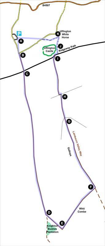
Exit the car park via any of the pedestrian exits along the eastern boundary but then keep to your right - skirting the car park to the picnic area (A) at the top corner. From here, cross south to the gate (B) in the SW corner of the open pasture. Cross the road to the track opposite. In 300m, cross the Ridgeway Path and continue for 2.8 km south to Knighton Bushes (a small wood - D). Once there, take the bridle way on your left skirting the northern boundary of the wood. After 330m, bear left (E) onto the track ascending the side of Whit Combe. At the top of Whit Combe (F) bear left onto the Lambourn Valley Way and follow this 1.5km to a gate (G). Go through the gate, still following the Lambourn Valley Way and, after 500m, cross through a gap (H) into a large field. Turn left but almost immediately right following the field boundary until you reach the Ridgeway Path (I). Once on the Ridgeway, bear right for 50m before turning left through the gate onto White Horse Hill. Cross to the concrete trig point facing you (J) and, on reaching it, bear slightly right following the path to the top of the White Horse itself (K). Then return to the car park via the path crossing Dragon Hill Road.