
Uffington / Knighton / Ridgeway

An 11.5 km circular walk from Uffington via Woolstone, Knighton and White Horse Hill.
See below for walk instructions
Buy a detailed map from the Ordnance Survey online shop.
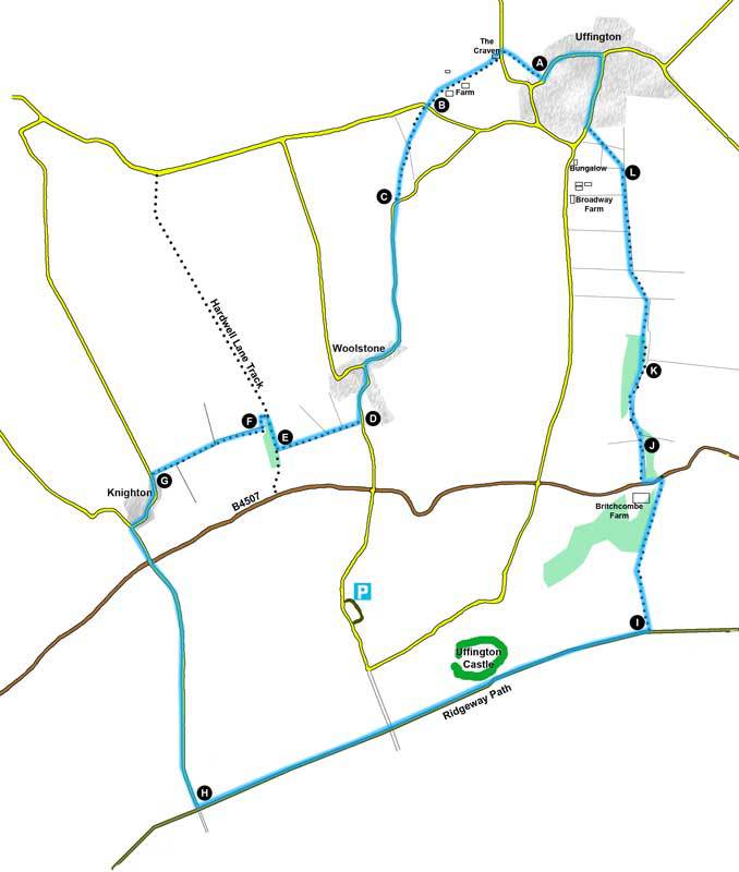
Park tidily in Uffington. Locate the Church (A) and enter the Churchyard through the iron gate way adjacent to the school playground. Follow the path past the Church’s main door straight on to a kissing gate at the far end. Once through the gate, continue across the field keeping the hedge to your left. After approx 150m you will cross a stile and see a bridge on your left. Cross it and a small area of grass to The Craven B&B on the opposite side of the roadway. The right-of-way crosses the front garden of The Craven, over the adjacent stile. It then splits into two paths - take the left hand path SW across the field. This continues in a straight line passing to the right of the main farm buildings and, about 120m beyond, intersects a hedge. Locate the gap in the hedge and the small bridge, crossing same to the roadway (B).
Cross the stile on the opposite side of the road and cross the field to a point approx ½ way along the field boundary on your far right. The path passes through this boundary, over another small bridge into scrub land (wet at certain times of year). Follow the path through the scrub land to a gate where it joins a road (C). Turn right and follow the road to the T junction by the White Horse pub in Woolstone. Turn left and continue up the road past the houses and the entrance to Woolstone Farm. About 150m on up the hill you will come to a stile and footpath on your right hand side (D).
Follow this path through several gates keeping the field boundary on your left until you reach Hardwell Lane Track (E). Bear right along the track for approx 100m then take the footbridge over the stream on your left. Once over the bridge, turn left and continue with the field boundary on your left. Approx 50m after the field boundary kinks right, you will need to cross the stile into another field on your left (F). Continue towards the west but now with the field boundary on your right. After 250m, you will encounter another stile taking you back across the field boundary. Again, continue westwards – this time with the boundary back on your left. When you reach the road (G), follow it left up through Knighton village. Turn left at the T junction up the tree-lined road. After 200m, cross the B4507 and continue up the road facing you. After 1.3 km, you will reach the Ridgeway Path (H).
You will now turn left, staying on the Ridgeway for approx 2.5 km. You will pass the grassy slopes of Uffington Castle on your left and, a further 800m on, you will see a footpath signposted to your left (I). Turn on to this path and some 450m on, you will pass through a kissing gate and descend quite sharply with the field boundary on your left. After a further 300m, and just before a partially hidden building in front of you, you will pass through another gate and descend a short, steep path to the B4507 adjacent to Britchcombe Farm.
Follow the road left for 80m then cross (carefully!) to a footpath on the opposite side. Follow this (with the camping field on your left and the field boundary immediately on your right) for 350m to a stile/gate on your right (J). Cross over and turn left. With the wood on your left, cross one stile and, just before you reach the next field boundary (K), go left over a bridge into the wood. Bear right immediately and follow the path through the wood. On emerging into a plantation of young trees (L), keep going in the same direction (north) crossing several stiles/gates as you approach Uffington. 900m after leaving the wood, after passing the house and barns of Broadway Farm you will enter a field with a bungalow on your distant left. Here, cross two fields diagonally to a gate opposite farm buildings. Once through the gate, follow the road around Uffington village to your starting point.